 We
were in Malaysia from the 24th September to the 8th December 2004. We arrived
by ferry from Satun, Thailand via Langkawi and left by ferry from Tanjung Belungkur
to Changi in Singapore.
We
were in Malaysia from the 24th September to the 8th December 2004. We arrived
by ferry from Satun, Thailand via Langkawi and left by ferry from Tanjung Belungkur
to Changi in Singapore.We
were in Malaysia from the 24th September to the 8th December 2004. We arrived
by ferry from Satun, Thailand via Langkawi and left by ferry from Tanjung Belungkur
to Changi in Singapore.
EU citizens may stay in Malaysia for 3 months. Your passport is stamped on arrival in the country, no visa is needed.
In Penang I am told there is a reasonable bike shop on Caernarvon Street, on the left hand side as you walk away from the Komtar tower. The email address is garycci@tm.net.my. I visited it but found it shut at 10am.
The best maps of the whole country we could find were at a scale of 1:915,000. There are also maps of each state, but while these are at larger scales they don't show much more detail. There simply aren't many roads.
Almost all hotels are signed in English, occasionally you will see "Rumah Rihat" which means guesthouse. Typical costs range from $5 to $15, for around $10 you can expect air-con and an en-suite bathroom with hot water. Camping in the jungle isn't much fun because it is too hot and the mosquitos are troublesome. It would be better with a "basha" (a combination of a hammock, a mosquito net and a tarp). We had a nice night's camping in the Cameron Highlands at 1000m altitude.
I bought a Hotlink SIM card from Maxis. It supports countrywide GPRS access using the following settings:
| APN | net |
| Username | maxis |
| Password | wap |
Unlike the Thai offerings, full internet access is available by GPRS. Coverage seemed good in populated areas, but poor in the countryside even on main roads. GPRS calls cost about 1.5 cents per kilobyte.
We are ashamed to admit that we learnt very little Malaysian indeed. Most Malaysians speak some English and only when you are truly off the beaten path will you need to know the name of what you want to eat in Malaysian. Malaysian has a simple grammar, is written in the Roman alphabet and has many English words, so it should be easy to learn. Road signs are in usually in Malaysian only, these may be useful:
Pusat Bandar - Town centre
Simpang Ke... - Junction for...
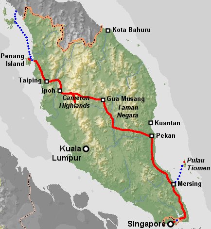
Penang to the Cameron Highlands
We took the ferry from Satun in Thailand via Langkawi to Penang. No charge was made for carrying the bikes (although I think they sometimes do) and there was no problem with them on the ferry.
We took the car ferry from the Jeti in Penang to Butterworth. You just ride on along with a load of mopeds, there is no charge when leaving Penang. Then we followed highway 1 southwards. It was busy, smelly, often a little narrow and not very well surfaced, we didn't enjoy it. That evening we stayed with a Malaysian cycle tourist who lives on highway 1 just south of Parit Buntar, about 45km from Butterworth. His name is David, and he is always pleased to meet and put up cycle tourists - give him a ring if you are going to be passing! His email is david_munusamy@yahoo.com and his mobile number is 019 4754622. At his house we met a French cyclist, Cedric, who had ridden from Penang the previous day via the bridge and the expressway. He said the bridge was too narrow but that the expressway was OK and the police saw him but didn't bother him.
March 2005. David has now opened a cyclists guesthouse in his home. The address is: 59,Jalan Bangau Dua, Taman Minamah, Nibong Tebal. Penang, Malaysia, telephone and email as above. His website is: www.bicycletouringmalaysia.com
From Parit Buntar we rode to Taiping (nice zoo) and then to Kuala Kangsar. The cycling experience was better than the first day, but the road was still pretty busy. Then we rode into Ipoh which was very busy for the last ten kilometers. From Ipoh we went south on highway 1 (head out of town on Jalan Gopeng) as far as Simpang Pulai (10km from Ipoh centre) where there is a clear sign pointing east down the new road to the Cameron Highlands. It is 60km with 1400m of height gain from there to Kampung Raja and there is no food or accomodation en route, but camping is easy and there are plenty of streams (probably OK to drink but best treated, we were there during the rainy season so there will be less at other times of the year). The road is fairly quiet except during peak holiday times and very scenic with a wide shoulder - great cycling! In Kampung Raja there are plenty of restaurants but no accomodation as far as we know, it is another 15km south to Brinchang or 20km to Tanah Rata before you will find a hotel. The Cameron Highlands are a lovely place to relax away from the heat of the rest of Malaysia.
We re-traced our tyre tracks north to Kampung Raja and then turned east towards Gua Musang. After a few kilometers the road went steeply down, signs indicated a gradient of up to 15% and our rims got very hot! We camped about 40km from Kampung Raja, be warned that there are very few streams near this road and no cafes, so you must take plenty of water. Next day we continued over gentle hills to Gua Musang, the first shade we came to was a shelter outside a roadside mosque about 40km from Gua Musang, 15km further on we came to the first cafe since Kampung Raja. The road was beautifully quiet until 15km from Gua Musang, well made and very scenic.
From Gua Musang we rode south on highway 8 which was fairly quiet and has some cafes. There is a guesthouse (signed only in Malaysian, "Rumah Rihat") at Merapoh, 28km from Gua Musang. From Merapoh you can go 7km east to Sungai Relau, a new entrance to the Taman Negara National Park. There is reasonably priced accomodation here and also 10km inside the park down a 4WD track. I don't know if it would be allowed to cycle down the track or what it is like. We went straight south down highway 8 to Kuala Lipis, it is 95km from Merapoh without any accomodation but there are a number of cafes. The road is mostly rather narrow and it was busy when we rode it, but it was the last day of a Malaysian holiday so everyone was heading home to Kuala Lumpur. There is one short steep hill 35km from Merapoh and plenty of gentle up and down.
From Kuala Lipis we pedalled to Jarantut, generally known as the gateway to Taman Negara National Park. About 15km before Jarantut we passed the Kuala Tembeling jetty where boats run to the park headquarters, there may also be a road to the park from here, I'm not sure. We stayed in the Sri Emas Hotel in Jarantut (15RM for a room) and went on a three day trip to the park organised by them. Then we rode east and then south via the town of Jengka to Maran. There definitely is a road to the park which goes north from highway 64 about 10km east of Jerantut, it is 62km to the park headquarters and the adjacent village of Kuala Tahan where there is accomodation from 10RM for a dorm bed. There is accomodation at the Plantation Resort, 31km east of Jerantut on highway 64, probably expensive. There is also accomodation at the Mercu View Resort in Jengka, but the cheapest is 65RM for a chalet. We opted to hang our mosquito net in a rather cheaper disused shack, it is was on the south side of the road, 100m west of the Kuantan 86km post on highway 2, about 8km west of Maran. People told us there was no accomodation in Maran, but we saw signs for a golf resort, can't be cheap. Highway 2 is fairly busy and too narrow for a bike, a car and a truck to pass together.
From our shack near Maran we went into town for breakfast. We left Maran on highway 2 towards Kuantan, but turned off south in the outskirts of Maran on to the C133 (marked as C21 on our map, but as C133 on the ground). After a few kilometers the tarmac was replaced by hard core for about 10km, then reappeared. Just before a bridge across the Pahang river we took a left turn on to a muddy track that brought us out on a part built road heading east along the north bank of the river. This took us to the village of Belimbing where we rejoined the tarmac on road C19, after a few km we turned on to the C106 following the river eastwards. This road was delightfully quiet and we saw hornbills, kingfishers and monkeys. Even now this is a great alternative to highway 2, when the road construction is finished it will be perfect!
We crossed the Pahang river on highway 12 (which was busy and fairly narrow) and then turned east again on highway 82, this time following the south bank of the river. This was another stretch of wildlife watching road, with egrets, an eagle and picturesque grazing water buffalo, traffic was light. From Maran to Pekan by this route is about 105km.
We headed south from Pekan on highway 3, it was flat and not too busy. For the 120km to the Tiomen jetty at Tanjung Gemok the road is flat, close to the sea and has beach resort accomodation nearby at fairly frequent intervals. In particular there is a choice of accomodation at Nenasi, Kuala Rompin and Tanjung Gemok. Tanjung Gemok is about 40km south of Kuala Rompin and has a ferry terminal with three boats a day to Pulau Tiomen, closed November to February.
A few kilometers south of Tanjung Gemok the landscape begins to roll at little and the road goes away from the sea. In Mersing there is plenty of accomodation and a year round ferry to Pulau Tiomen which takes bikes without fuss. After four days off on Tiomen (great snorkeling) we rode south towards Kota Tinggi. 65km from Mersing, 30km before Kota Tinggi we stopped at a restaurant and motel (no sign on the main road) where we got a somewhat dirty and mosquito ridden chalet for a rather excessive 60RM. We also saw a sign advertising chalets and dorms about 500m north of the junction between highway 3 and highway 99, 16km north of Kota Tinggi. We turned off highway 3 at this junction and headed for the Desaru seaside resort. The road was not busy but rather narrow and in holiday season might be very unpleasant. The cheapest accomodation we could find in Desaru was chalets for 100RM, so we camped on the beach.
In the morning we cycled to the ferry terminal at Tanjung Belungkur (roughly due west of Desaru) and took a ferry to Changi in Singapore. There was no problem with the bikes but we had to pay a 10RM charge for each one. Once in Singapore we took the Changi Coast Road south-west along the airport perimeter. Just before it joins the East Coast Parkway we turned off and rode through the East Coast Park. This is a great section with perfect cycle paths and lots of local families out enjoying themselves on bikes and roller blades. From the end of the park you can join the East Coast Parkway (an expressway) for the final few kilometers into the centre, or you can go north, cross the Gelong river by a footbridge, then cross the Kalang by the Nicoll Highway and then follow paths along the waterfront past the Esplanades and up the Singapore river. Because of these cycle paths we thought Singapore was the best city we had cycled into.